Morecambeology Episode 50: Smoke and Fire by Peter Wade

Great Fire

The flawless blue skies of the past week have been marred only by the smoke plumes from the moorland fires well to the south. Smoke from the fire on Saddleworth Moor appeared first on Wednesday as a smudge along the southern horizon only to be joined on Thursday by the nearer plume from Winter Hill. This rose in the south east and was carried westwards to form a background to the offshore wind farm across the bay.

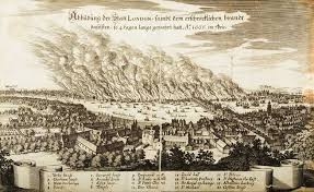
In September 1666 the Great Fire of London followed hot on the heels of the Great Plague. The pall of smoke towered like ghostly sails over the city and was carried westwards by the wind some 50 miles. By night, the sky glowed blood red.

In 1698, Lancaster suffered its own Great Fire when at least 20 houses along Church Street were destroyed. Just as London had its diarists in the form of Samuel Pepys and John Evelyn to record events, so Lancaster had the Quaker merchant William Stout who recorded how the fire started at 9am on Monday 2nd February when a spark from some un-quenched ashes jumped into straw roof thatch. Dry weather and an easterly wind carrying further sparks meant a rapid spread from one wooden thatched building to the next until a more substantial stone-built, slated building brought the fire to a halt.

The fire kept to the northern side of Church Street. However the speed of spread was such that the 31 people caught up in the fire had time only to save themselves.

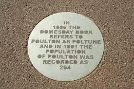
From a distance, the inhabitants of Poulton, Bare and Torrisholme might have seen and smelt the pall of smoke from the fire and possibly heard its crack and roar carried on the wind.

Their houses were though as much at risk as their Lancaster neighbours with the same construction of wooden frames and thatched roofs.

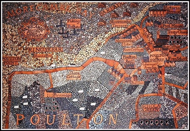
A few though were ahead of the game. Stone-built Park Farm in Poulton Square is Morecambe’s oldest dated building at 1685. Also in the running is Moss House Farm in Morecambe’s West End of 1697 on Regent Park Avenue, a house in Torrisholme Square from 1663 and a farmhouse on Thorpe Avenue from 1687. Several outlying farmhouses or halls also date from the 1690s/1700s and would have been at least in part made of fire resistant materials as would Poulton Hall back in the heart of Morecambe.

Morecambeology Episode 42: In a Domesday Landscape by Peter Wade

Domesday

The names of the villages that were to merge to become Morecambe – Poulton, Bare and Torrisholme – were first written down in the Domesday Book of 1086. This was a measure of the wealth William 1, Duke of Normandy, had gained from the Norman Conquest 20 years before and also a record of how it was to be parcelled up as a reward for his loyal barons.

Poulton was not only named (Poltune) but measured at 2 carucates. A carucate was a unit of area (the area 8 oxen could plough in a year) equivalent to about 120 acres.

The carucate was primarily an accounting device, enough to generate about £1 in revenues each year. The carucate also gives an insight into the population of the time because a carucate is said to have been enough to support a household. ‘Household’ is a vague term but, being generous, perhaps sets a very round upper limit on the population of Poulton at a hundred.

Strangely, Poulton and its neighbours are not recorded as part of Lancaster but rather as part of the Manor of Halton which extended either side of the River Lune and its estuary, and a little way upstream of Halton itself. Lancaster, the main settlement in the area lay roughly at its centre so some, perhaps temporary, circumstance seems to have counted against Lancaster at the time Domesday was compiled. Rebellion and in-fighting followed the Conquest well into the next century, and Lancaster may have been caught by Domesday’s snapshot in the midst of one of these episodes.

Whatever misfortune befell Lancaster pales by comparison with the Harrying of the North of 1069-1070 when William’s forces swept through Yorkshire, Northumberland and Durham putting down any signs of resistance and laying waste large areas. It is estimated that 100,000 died in the resulting famine with bodies left unburied in a desolate landscape stalked by wild boars and robbers.

Lancaster’s old Roman fort would at the time of Domesday have been a ruin and nothing similarly robust would come until the building of the keep of the present castle in the mid 12th century, so Lancaster would have seemed relatively undefended. At best it might have had defensive earthworks dug and a motte and bailey castle erected with little more than wooden palisades for protection. A string of these castles dotted the Lune Valley as far as Kirkby Lonsdale, including one at Halton.

Away from any protective castle and garrison, villages like Poulton would have been literally open to attack from any would-be raiders. Their saving grace was that they were positioned just off the main north/south route commanded by Lancaster, which perhaps spared them from all but the most major incursions.

Morecambeology Episode 39: Doorways to Poulton’s Past by Peter Wade

Morecambeology 39 - Poulton Arch

Poulton Arch stands alone as a curious relic in its little park on Poulton Road. It looks more like a castle gateway than what it really is – a 13th century doorway to the manor house of Poulton-le-Sands. The rest of Poulton Hall vanished in 1932 when it was demolished to make way for an open air market and coach park.

In old pictures the hall is hard to make out, appearing largely covered in ivy. Much of it is described as 17th century in common with other stone buildings such as Park Farm in Poulton Square.

When the monasteries were dissolved in the 1530s, the Manor of Poulton was divided in three. One of the families to take a one third share were the Washingtons, ancestors of the first President of the USA. Residents of Poulton Hall following on included the Nicholsons, Eidsforths and Tillys.

The archway was rebuilt behind Morecambe Town Hall in 1932 complete with doors and a plaque below. The plaque is still there but hard to make out. It reads as follows:

This doorway was preserved from the old Poulton Hall which until 1932 was the original entrance to the Manor House of Poulton le Sands owned in part during the 15th and 16th centuries by President George Washington’s direct paternal ancestors whose main residence was in Warton.

The arch was returned to its original site in 1997 when the market area was re-developed. Its plaque was left in place though, a memorial not to the arch but its temporary move.

A second archway is to be found through the opening to Morecambe cemetery. It was the doorway from Rose Cottage (sometimes referred to as Pear Tree Cottage) which was also demolished in 1932, this time because it caused a narrowing of Lord Street where it jutted out into the roadway. The initials on the door lintel refer to its first residents, Edmond and Agnes Simpson.

A short film Poulton Lost and Found is available now on www.lunetube.co.uk featuring Poulton’s archways.

OUR FAMOUS MORECAMBEOLOGIST REVEALED!!!

Morecambeology Revealled - Peter Wade

Morecambe Heritage lifts the lid on our self-styled Morecambeologist and asks who is Peter Wade?

* * * * *

Peter

* * * * *

Was born on Trafalgar Day a few years before the beginning of the Space Age

Lives in a 1930s semi originally rented by his grandparents

Is about to start his 23rd season of guided walks in and around Morecambe, Heysham and Lancaster

Is a cross between a Yorkshire Terrier and a Great Dane (or so his mum always said, not sure his dad agreed)

Is currently reading The Pantomime Life of Joseph Grimaldi by Andrew McConnell Stott, a book borrowed from Heysham Library

Was born in the Queen Vic, so can claim to be a sand grown ‘un

Is contemplating the switch from winter soups to summer salads

Was schooled at Sandylands Mixed Infants and Morecambe Grammar

Is currently listening to London Grammar’s 2013 album If you wait and recordings of The Beggar’s Opera, both part of a growing vinyl collection

Finished his formal education at Warwick University with a joint degree in Physics and Philosophy

Leads the team at the Winter Gardens hosting paranormal investigations, a major fundraising activity

Has had a varied career in education ranging from the Adult Education Centre in Morecambe to Lancaster University

Is an occasional LuneTube presenter. His first attempt, Poulton – a Place of Pebbles has had over a thousand views. Others in the pipeline are about war memorials in Heysham, lost buildings in Poulton and Carnforth’s iron industry

Has designed and painted scenery for Lancaster Footlights and the Grand theatre. Plays include Brecht’s The Life of Galileo, Molière’s Tartuffe, and Oscar Wilde’s Lady Windermere’s Fan as well as many pantomimes and touring shows.

Is currently writing his next column for the July/August issue of Popular Astronomy , a magazine he has contributed to for over 30 years

Can often be found helping out at Morecambe Heritage Centre

Has written several booklets about aspects of the area’s history, one of which (Echoes of Art Deco) has sold over 3,000 copies

Leads tours of the Winter Gardens and Morecambe Town Hall

Used to walk regularly to and from Lancaster University, much to the amazement of his head of department

Has a royal coat of arms over his bed, salvaged from a production of Alan Bennett’s The Madness of George III

Once did a Roman route march following the Roman road over High Street from Ambleside to Penrith

Is to paint Lancaster Grand Theatre’s new safety curtain in a rococo style over the summer (the keen-sighted may have spotted the initials PW in the corner of the old one)

Morecambeology Revealled - Grand

Morecambeology Episode 36: Crossing the Sands by Peter Wade

Morecambeology 36 - Turner

Fisherman’s Square behind the old red brick Art and Technical School was once home to Morecambe Trawlers’ Cooperative Society. Today it is marked out as a map of Morecambe Bay centred on the three fishes, an old emblem of Poulton-le-Sands. The surroundings represent the rivers that drain into the bay: the Duddon, Leven, Kent, Keer, Lune and Wyre.

Old maps of Lancashire focus on these individual channels and the sand banks in between – Kent Sand, Lancaster Sands and Cartmel Wharf – rather than the bay as a whole.

Maps from the 1750s onwards also show the route across the sands, the Hest Bank Passage connecting Hest Bank to Grange-over-Sands, a route described as being fordable at low water.

Then as now, the way across the sands was overseen by an official guide whose job it was to test the route, mark it with sticks and blow a signal on a horn to mark the beginning and end of the period in which the crossing could be safely undertaken. Despite its obvious dangers, the route was popular with travellers wanting to pass directly to and from Lancashire North of the Sands. It only began to decline with the opening of the Furness Railway in 1846.

Among those who made the crossing were poet William Wordsworth and gothic novelist Ann Radcliffe. Another traveller was the painter JMW Turner who produced two watercolours showing travellers making the crossing – Crossing Lancaster Sands (now in the collection of Birmingham Museum and Art Gallery) and Arriving Hest Bank, Lancaster (British Museum).

Modern cross bay walks are conducted under the direction of The Queen’s guide to the sands, Cedric Robinson.

__________________________________________________________________________________________

MORECAMBEOLOGY GOES LIVE! A guided walk, Poulton and Old Morecambe, starts from the Police Station in Poulton Square at 2pm this Saturday March 31. The walk includes a Victorian cemetery, two town halls and two famous Morecambe men – the artist William woodhouse and the Cambridge geologist John Edward Marr. Places on the walk are priced £3 per person. For further details contact the tour guide Peter Wade, telephone 01524 420905.

Morecambeology 30: Poulton’s Pebbly Past by Peter Wade

Morecambeology 30 - Poulton

Hidden away inside Morecambe Lifeboat Station is a very handsome picture of Poulton-le-Sands (image courtesy of David Chandler) set out as a map from the mid 19th century. The unusual thing about the map is that much of it is made of decorative pebbles, the sort of thing you might collect yourself from the beach.

The map, which hung originally in the local branch of the Bradford & Bingley Building Society, combines the familiar with the unfamiliar. Poulton Square is easily recognisable along with the Parish church, Bull Inn and Morecambe Hotel but then there are unexpected items such as Poulton Hall (now vanished aside from its doorway), the Fishermen’s Arms (now the Smugglers Den) and Rose Cottage which stood on Lord Street until it was demolished in the 1930s.

Another connection between the map and Poulton-le-Sands lies in the pebbles themselves. Just as the map is made of pebbles, much of the village was made of stones and pebbles collected from the beach. There were no quarries very nearby so building stone for such things as window or door surrounds had to be brought by horse and cart from the nearest ones which were in Lancaster. For the rest, the beach offered a ready and free source of building material.

Local builders were adept at re-cycling as we might call it today. Roof timbers would be salvaged from demolished buildings and, if necessary, pegged or nailed together to span a greater width.

To see Poulton’s pebbly past for yourself, take a stroll up and down Lord Street or else take a look at the latest LuneTube offering “Poulton – a place of pebbles” on http://www.lunetube.co.uk

Morecambeology Episode 25: A Treasure Trove of Names by Peter Wade

Morecambeology 25 - Torrisholme Barrow

We get excited by news of buried hoards and so on, but place names are a kind of hoard or time capsule as well, leaving messages from the past and the people who went before us.

The earliest names to have survived locally are from Roman times such as Moricambe Aestium (Morecambe Estuary) as we saw in Morecambeology 19.

Many of our local place names come from the people who moved in once the Romans had left. Poulton is a classic example of an Anglo Saxon name with the ending ton meaning farm or settlement. Less obviously Anglo Saxon is Bare meaning a grove of trees. Other Anglo Saxon names nearby include Heysham (estate in a wood), Middleton (middle farm), Overton (upper or further farm) and Sunderland (separate land).

The Angles and Saxons were originally from southern Jutland and northern Germany, and may have settled locally as early as the 6th century AD.

From the 9th century another group of migrants, the Vikings, began to make their mark, at first as raiders and later perhaps as settlers. Torrisholme is an obvious Viking name with its ending holme meaning island. It may not though literally mean an island surrounded by water, perhaps instead higher and drier land rising out of marshes. The first part is someone’s name such as Thorald or Torvald.

Another of these islands, Trailholme, marks a farm on a slight rise on the way to Sunderland Point while Anstable Holme referred to the rise on Lancaster Road before the Shrimp Roundabout.

Other Viking names are to be found in Schola Green Lane which comes from shieling meaning grazing land, Mears Beck (a stream or beck which drained onto Sandylands), White Lund (the white grove) and, out in Morecambe Bay, the skears or skerries (rocky outcrops left from hills which have been eroded away by the sea). This last word conjures up ideas of both Viking ships sailing the bay and of an even older landscape lost to the waves.


Morecambeology Part 19: Putting Morecambe on the Map by Peter Wade

Morecambeology 19 - map

Old maps are as attractive as decorative objects as they are for the information they contain. In 2013 the Centre for North-West Regional Studies at Lancaster University published a very handsome review of the first 200 years of printed maps of Lancashire compiled by Ian Saunders.

The first map actually has its origins well before this period, a map of 1578 by Gerard Mercator based on one by Ptolemy produced in 120-160 AD. This shows a rather tortured version of the British Isles set at the very edge of the known world with sea monsters not too far away. On the NW coast of England is shown the Moricambe estuarium which, though hard to identify precisely with what we know as Morecambe Bay, is at least the source of its name.

Local place names were first written down in the compilation of the Domesday Book of 1086. This was an uncertain process based on writing down what local people said places were called. In the Morecambe area, the three villages that we now know as Poulton, Bare and Torrisholme were recorded as Poltune, Bare and Toredholme. In the years following, all three spellings would undergo variations.

Poulton and Bare were the least altered. In the first half of the 17th century Poulton was Potton, then Polton and finally from 1695 the modern form of Poulton. Bare varied slightly over time too: Bar, Barr, Bore and then Bare from 1787.

Torrisholme is the most varied, not least because its final letter kept appearing and disappearing. Thorisholme is the spelling from about 1600, then Therisholm, Thurisholm, Torrisholm and finally Torrisholme on William Yates’ first large-scale map of Lancashire of 1787. This map records individual buildings for the first time, indicating the layout of villages and roads. A few buildings are even named such as the chapel in Poulton and Torrisholme Hall.

Importantly, Yates’ map re-introduced the name Morecambe Bay for the first time since Ptolemy.


Morecambeology Part 6: Stormy Weather with Peter Wade ;-)

Morecambeology 6 - West End Pier

The clue is in the name: Poulton – a settlement by a pond or pool. With no sea defences as such, Poulton and its neighbours had to make the most of the landscape, setting themselves on hills or behind higher ground, seeking shelter from storm and flood.

Caught between the sea and storms on one side and the flood plain of the Lune estuary on the other, there must have been many past inundations which have gone unrecorded.

From the 1850s onwards as Morecambe began to be established, there are regular reports of damage to new sea walls, wind damage and flooding (some as far inland as what is now the Shrimp Roundabout.

Many people still remember the storm of 1977 with gales of up to 92 mph and widespread flooding as the central promenade was breached. The most notable casualty was the West End Pier. This had suffered various mishaps over the years but finally fell victim to the storm, apparently because it had been fixed too rigidly to the promenade – with a bit more flexibility it might have survived. The morning after, the beach was alive with scavengers, many searching for pennies lost overboard from the slot machines.

Another notable storm took place on Mothering Sunday in 1907. A spring tide, south westerly gale and the Lune in flood after a month’s rainfall all combined to cause a breach in the West End promenade and widespread flooding inland. Around the Stone Jetty stone blocks were thrown about by the waves and the workshops of Wards Shipbreakers were damaged. The Ben-my-Chree, a paddle steamer with the Isle of Man Steam Packet Company awaiting scrapping, broke its moorings and had to be scuppered to stop it being carried away.

Inland there was flooding around Charles Street and Out Moss Lane resulting in the loss of livestock, as well as floods on White Lund, around Woodhill, Overton and Snatchems. Food and supplies had to be brought to stranded householders by boat.

Along Sandylands, front gardens were wrecked, and cellars and lower floors flooded. Furniture was to be seen floating down streets (a similar sight was reported in Parliament Street in 1977).

Sandylands Promenade was again wrecked by a storm at the very end of 1925. Its repair and, more importantly, its repair bill, led to the amalgamation of Morecambe and Heysham in 1928.